
Colorado GMU 65 elk: terrain, access and seasons
From the Cimarron drainages to the peaks above Ouray: what the public data says about the unit, each number dated.
Glassline is our product. Where it appears below, that's why.
Unit 65 by the numbers
| Unit 65 | Data | |
|---|---|---|
| Herd (Cimarron, E-35) | 7,220 post-hunt · 6,570 in 2019 2025 | 2025 |
| Bull:cow ratio | 30:100 · 19–30 since 2019 2025 | 2025 |
| Success, all seasons | 25% of 3,000 hunters · 24% in 2025 (herd-level estimate) 2024 | 2024 |
| Success, archery | 8–15% 2022–2024 | 2022–2024 |
| Success, muzzleloader | 8–17% 2022–2024 | 2022–2024 |
| Success, first rifle | 27–33% 2022–2024 | 2022–2024 |
| Success, second rifle | 23–25% 2022–2024 | 2022–2024 |
| Success, third rifle | 14–31% 2022–2024 | 2022–2024 |
| Success, fourth rifle | 22–50% 2022–2024 | 2022–2024 |
| Hunter density | 22 hunter-days per sq mi, all seasons 2024 | 2024 |
| Huntable public land | 53% · Forest Service 40%, BLM 10%, state 3% 2026 | 2026 |
| Access | 36 trailheads · 673 mi of roads · 327 mi of trail 2026 | 2026 |
| Forest roads (MVUM) | 120 mi · 35 mi with a seasonal window USFS | USFS |
| CPW seasonal range maps | summer 74% · winter 49% · severe winter 17% · calving 22% of the unit CPW | CPW |
| Elevation | 5,800–14,300 ft 3DEP | 3DEP |
| Burns since 2020 | Gold Mountain (2026), ~39,700 ac 2026 | 2026 |
| Wilderness | Uncompahgre, 94 sq mi · Mount Sneffels, 10 sq mi | |
| SNOTEL stations | Idarado 9,780′ · Red Mountain Pass 11,060′ (0.4 mi out) · Mineral Creek 10,030′ (3.4 mi out) · Alta Lakes 11,290′ (5.9 mi out) | |
| Over the counter | Archery either sex for residents, Sep 2–30 · second rifle bull, Oct 24–Nov 1 · third rifle bull, Nov 7–15 2026 | 2026 |
Herd numbers cover the whole Cimarron herd unit, which can span several game units. Harvest and access figures are this unit's own. Data pulled 2026-10-04.
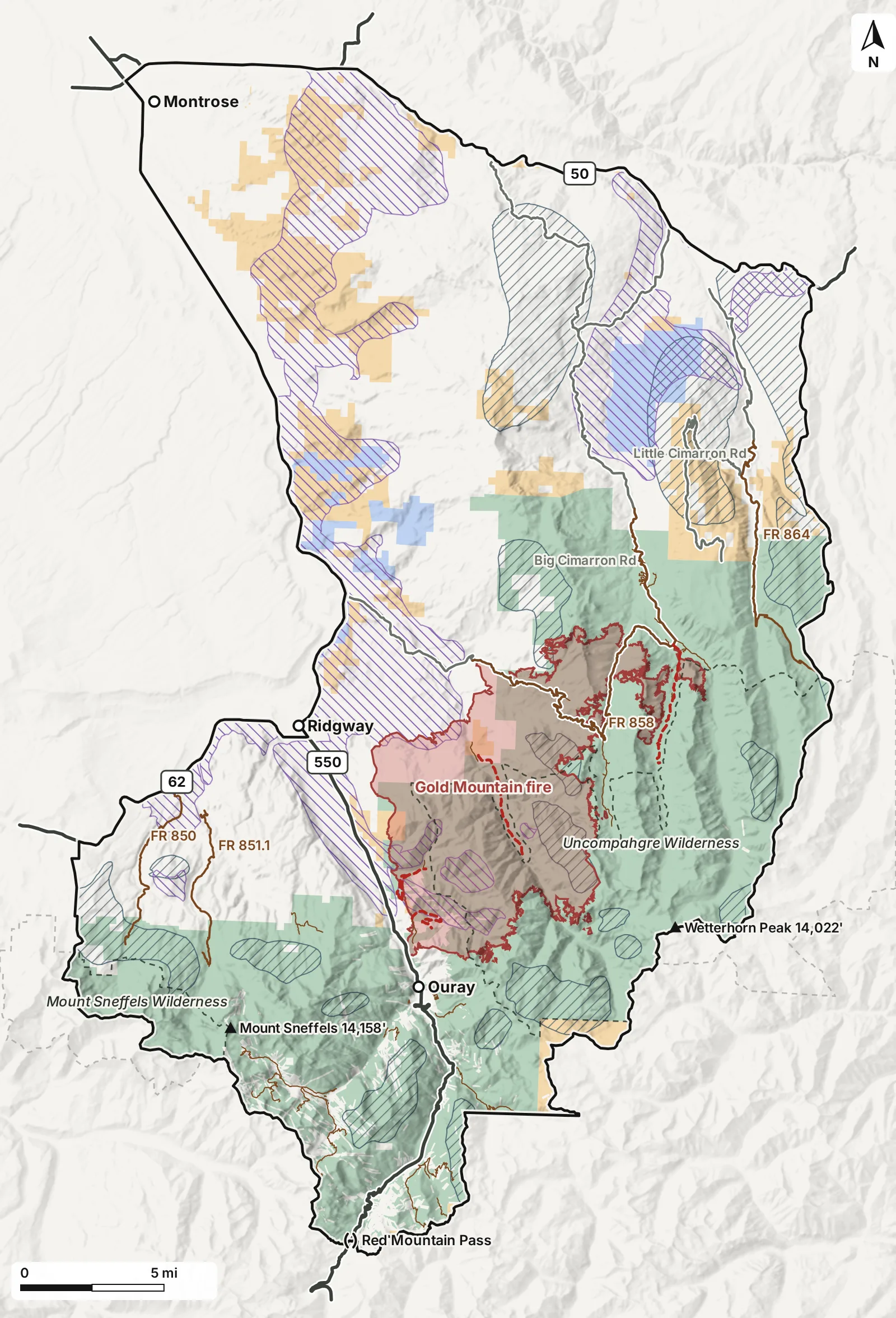
Unit 65 on the map
Land
- Unit boundary
- National forest
- BLM
- State land, CPW
- No public hunting access
- Wilderness
CPW mapped elk ranges (2025)
- Summer concentration area
- Winter concentration area
Roads
- Highway
- County road
- Forest road (MVUM)
- Fire closure through May 31, 2027
- Mountain pass
Fire
- Gold Mountain perimeter (2026)
Where is Unit 65?
Unit 65 covers about 672 square miles of west-central Colorado. US 50 runs along its north side between Montrose and Cimarron, and US 550 along much of its west side. The ground climbs from about 5,800 feet on the Uncompahgre valley floor to past 14,000 feet on Wetterhorn Peak and Mount Sneffels. About 94 square miles of the Uncompahgre Wilderness lie inside the unit, with a 10-square-mile slice of the Mount Sneffels Wilderness. Between the valley and the peaks sit the Big and Little Cimarron drainages, Cow Creek, Cedar Creek and the forks of Dallas Creek.
How much of it is public?
About 53% is mapped public hunting land, most of it national forest. Much of the remaining ground, including the ranch and farm country toward Montrose, has no public hunting access. That edge matters in the rifle seasons: in Montana, collared cow elk favored ground closed to public hunting over security cover once seasons opened (Proffitt et al., 2013).
The Owl Creek–Cimarron road (Forest Road 858) crosses the middle of the unit; the Little Cimarron and the East and West Dallas roads reach other drainages. Of about 120 miles of forest roads on the Motor Vehicle Use Map, 35 carry a seasonal window, so the map for your dates decides which are open to your vehicle.
What did the Gold Mountain fire change?
The Gold Mountain fire started June 27, 2026, northeast of Ouray and burned about 39,700 acres inside the unit. On September 15 the Forest Service reopened Owl Creek Pass, the West and East Forks of the Cimarron and the Silver Jack area. Its order 02-04-06-26-29 keeps the Middle Fork Cimarron, Cow Creek, Dexter Creek and Cutler roads and more than twenty trails closed through May 31, 2027 (GMUG, posted 2026-09-14). The current order is the one to read before planning an approach. A burn this fresh offers little feed yet; in a Montana study, forage quality rose in the second and third years after a large fire (Snobl et al., 2022).
What do the OTC rifle seasons look like?
For 2026, second and third rifle bull tags are over the counter in Unit 65 (Oct 24–Nov 1 and Nov 7–15); first and fourth rifle are draw. Second-rifle success held at 23 to 25 percent of hunters from 2022 to 2024; third rifle ran from 14 to 31 percent over the same years. Fall moves toward winter range tend to follow snow and hunting pressure rather than the calendar (Rickbeil et al., 2019), and CPW maps about half the unit as winter range. In rifle seasons, collared elk tended to hold about a mile or more from open motorized routes (Ranglack et al., 2017); in Unit 65, the wilderness and the steep country off the main forest roads match that profile.
How is the habitat in Unit 65?
Habitat quality isn’t static — it needs to be weighed against the season you’re hunting and the specific conditions this year. Glassline’s Habitat Score grades the unit in cells about 300 meters across on four factors, and in Unit 65 each one has something to grade:
- Food: burn regrowth (fires 1 to 15 years old count, most in years 2 to 5), meadows and parks, greenness, and which way slopes face for the season. The 2026 Gold Mountain burn is left out of hunt areas this season; its regrowth starts counting next year.
- Water: distance to year-round water, which here means the Cimarron forks and their tributaries, plus snowmelt and this year’s snowpack.
- Breeding cover: CPW’s mapped summer concentration areas (2025), wet seeps, open parks, and timber edges.
- Shelter: how many foot-effort hours a patch sits from the nearest road open to motor vehicles, and how big the remote block around it is. The Uncompahgre Wilderness, with no motorized routes, is the clear example in this unit.
The weights for each of these shift with the season: rifle seasons prioritize shelter, and a heavily hunted unit leans on it even more. This year’s snow, drought, recent rain and fire move them again.
The figures above, and the map, are what Glassline reads when it ranks hunt areas inside the unit for a hunter’s own tag, dates, and legs.
Sources
- Gold Mountain Wildfire Roads and Trails Closure Order v4.0 (Order 02-04-06-26-29) — Grand Mesa, Uncompahgre and Gunnison National Forests, posted 2026-09-14
- GMUG National Forests reduce Gold Mountain Fire closure area — West Slope Fire Info, 2026-09-14
- Security areas for elk during archery and rifle hunting seasons — Ranglack et al., Journal of Wildlife Management 81(5), 2017
- Effects of hunter access and habitat security on elk habitat selection in landscapes with a public and private land matrix — Proffitt et al., Journal of Wildlife Management 77(3), 2013
- Plasticity in elk migration timing is a response to changing environmental conditions — Rickbeil et al., Global Change Biology 25, 2019
- Wildfire extends the shelf life of elk nutritional resources regardless of fire severity — Snobl et al., Ecosphere 13(7), 2022
- Elk statistics: population estimates and harvest reports — Colorado Parks and Wildlife
- Colorado big game hunting: brochure, seasons and hunt codes — Colorado Parks and Wildlife
- COMaP: Colorado Ownership, Management and Protection — Colorado Natural Heritage Program
- COTREX: Colorado Trail Explorer — Colorado Parks and Wildlife
- Wildland Fire Interagency Geospatial Services (WFIGS) fire perimeters — National Interagency Fire Center
- SNOTEL network — USDA Natural Resources Conservation Service
- 3D Elevation Program (3DEP), 1/3 arc-second — U.S. Geological Survey
- Species Activity Mapping: elk seasonal ranges — Colorado Parks and Wildlife
- Motor Vehicle Use Maps (MVUM) — USDA Forest Service
- Highways and major roads — Colorado Department of Transportation