
What's under every play.
40+ datasets from 10+ agencies — read, scored and ranked against your profile before a single play is written.
Glassline reads the same public data any hunter can pull. It never uses real-time animal locations, collar data, or crowdsourced sightings — and it never will.
Elk seasonal range
Summer, winter and severe winter range, concentration areas, migration corridors, production areas
Mule deer seasonal range
Summer and winter range, severe winter range and winter concentration areas, migration corridors, highway crossings
Herd data
43 elk herd units: post-hunt population estimates, bull-to-cow and calf-to-cow ratios, trend and objective
Harvest records
Success rates, hunter counts, hunt codes, season dates, method of take
Terrain
Bare-earth ground and canopy height at 5m from lidar, on about 87% of unit area; slope, aspect, landform and roughness from 10m elevation models; the terrain horizon in 32 directions out to 15km
Vegetation
Canopy, shrub, grass and bare ground at 30m; vegetation type at 30m; July greenness against a 10-year baseline
Snow and water
118 SNOTEL stations reporting daily, snowpack persistence, ~1M stream segments, 5.8K springs
Fire history
Wildfire perimeters since 2020, post-fire browse zones, current-year fires and containment
Access and trails
135K+ miles of road, 23K+ miles of trail, 2.5K trailheads, ~200 developed campgrounds
Land ownership
8.5K public parcels — BLM, USFS, NPS, FWS, state wildlife areas and trust lands — with access status
Conditions
Daily snow readings, active fires, greenness anomalies
A public-lands map, not a parcel map
Ownership records cover public ground. Land with no record is treated as assumed-private and left out of the plan by default. You can manually create hunt areas on private land if you confirm you have permission.
Unverified two-tracks stay unverified
Roads and trails from every agency are merged into one access layer with vehicle class and seasonal windows attached. A two-track that no agency vouches for is flagged as unverified — a good candidate for confirmation in the field; not relied on by Glassline's routing.
Lidar where it's been flown
The LiDAR basemap and the lidar canopy read come from USGS flights between 2018 and 2024. About 13% of unit area has no lidar yet; there the map shows 10m relief under a light hatch. Both show the ground as it was flown, so a fire since then won't be in them.
What a pin actually means.
Bedding cover. Feeding area. Bench. Saddle. Wallow. Glassing point. Every marker in Glassline is a description of the ground and why it suits the season you're hunting — places worth checking, not animal locations. Glassline draws them from terrain, canopy, hydrography and season, then you modify them, add your own, and choose which to keep in your plan.
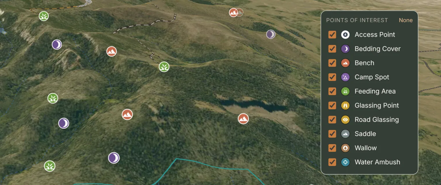
Detected from terrain
Slope, aspect, canopy, water and season are scored across the hunt area at 10m resolution.
You curate the set
Keep the candidates that match what you know, drop the ones that don't, and drop your own pins.
Plays are written around them
The pins you keep become the terrain your plays run in — with drive and hike routing and packout measured from the back of each one.
Feeding area
Open parks, meadow edges and burn regrowth, read from canopy cover and seasonal greenness. On deer hunts, shrub browse.
Bedding cover
North-facing dark timber and steep shelves where canopy closure and aspect hold cover through the day. On deer hunts, cover under rims.
Bench
Flat ground on a steep slope — the shelves that show up in 10m terrain data, not on a topo glance.
Saddle
Low points between drainages, where the terrain narrows into a natural corridor.
Wallow
Perennial seeps, springs and pond complexes in timber, from hydrography and slope. Elk hunts only.
Glassing point
Vantages with sight lines into the basin, scored for approach cover and morning light.
Water ambush
A setup on water, surfaced when the forecast turns hot and dry.
Camp
Legal, flat ground near water, inside the drive and hike limits you set.
$39.99/yr — first 500 hunters, rate locked.
Glassline maps the mountain, never the hunters.