
Reading slope, aspect and sun in Colorado elk country
What each terrain layer measures, the bands worth paying attention to, how to read them together on a topo, and their limits for e-scouting.
A topo map already holds the information you need to determine slope, aspect, and sun exposure. Tight contours are steep ground, the way the contours bend shows which way a face points, and a ridge to the east means a late sunrise. The benefit of terrain layers is it does all of this for you — reading every patch of ground ahead of time and painting the answer on the map so it’s much easier to read.
This guide covers what each layer measures, the bands to pay attention to, how to read them together, and their limits. The figures show one drainage in Unit 65, in the San Juans of southwest Colorado, about 9 kilometers (5.5 miles) across. They were made for this guide from U.S. Geological Survey elevation data, which records the height of the ground about every 10 meters (33 feet).
What does each layer actually measure?
All three start from the same thing: a grid of ground heights, called an elevation model. In Colorado the standard one comes from the USGS 3D Elevation Program and records the height of the ground about every 10 meters.
- Slope angle is how steep the ground is, in degrees from flat. Each reading is worked out from the ground around it, so it describes a patch about 30 meters (100 feet) across, and a short ledge or a very small bench can blur out. For reference, 45° is a 100% grade.
- Aspect is the compass direction a slope faces: 0° is north, 90° east, 180° south, 270° west. Flat ground has no aspect. The figures below call anything under 2° flat.
- Sun and shade is a model, not a measurement. Given a date, a time, and the sun’s position, it works out which ground the sun strikes directly and which sits in the shadow of terrain between it and the sun.
What bands do hunters read on a slope layer?
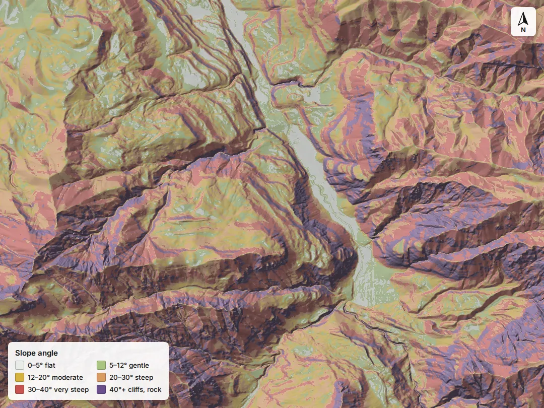
Six bands cover almost every decision a hunter makes about steepness:
- 0–5°: flat. Valley floors, parks, lakeshores and ridge-top saddles. Easy walking, often the most visible ground in the drainage.
- 5–12°: gentle. Benches, meadows and broad shelves. Gentle ground surrounded by steep ground is the classic bench: a small shelf partway up a face that is easy to cross and hard to see into from below.
- 12–20°: moderate. Sidehill travel is still reasonable.
- 20–30°: steep. Off-trail travel slows sharply, and every loaded step of a packout costs more.
- 30–40°: very steep. Hard going in any season. Once snow is on the ground, this is also the steepness where slab avalanches most often start, but slope angle is only one factor: the snowpack, recent weather and the terrain around and above a slope matter as much (Avalanche.org).
- 40°+: cliffs, chutes and rock.
The drainage in the figure is typical of the high San Juans. By area, half of it is steeper than 30° and just 14% is gentler than 12°. That ratio is the first thing a slope layer shows about a unit: how much of it can reasonably be hunted.
How steepness turns into time. A long-standing walking speed estimation model (Tobler’s hiking function) puts flat-trail walking near 3 mph. On a 10° climb it falls to about 1.7 mph, on 20° to about 0.9 mph, and on 30° to under half a mile an hour. Those are trail rates for an unloaded walker. Off trail, in timber or with a pack of meat, they are slower. The difference between a 12° approach and a 25° one is significant — it adds up to hours across a day.
Benches. On a slope layer a bench is easy to spot: a small island of the gentle color inside the steep colors, partway up a face. These flat shelves on steep faces are common areas for elk to bed, feed, or travel along, and they are often the only gentle ground for hundreds of yards.
How does aspect change the picture by season?
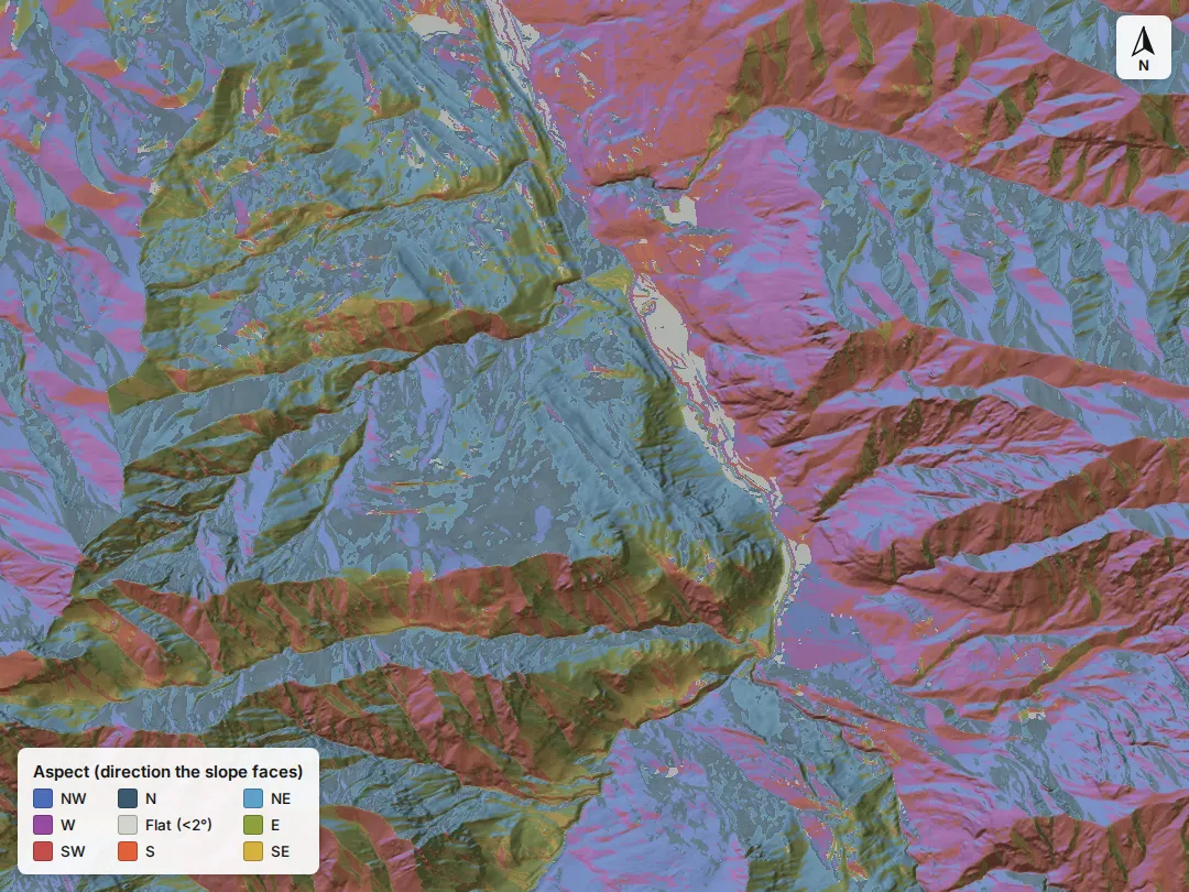
In Colorado, a south or southwest face takes far more sun through the day than a north face, and the gap widens as the sun sits lower in fall. Three seasonal patterns follow from that.
Early season heat. North and east faces stay cooler through a warm September or early October afternoon. A terrain layer can’t show heat, but aspect is a fair first guide to where the cool ground is. Studies of elk in heat found that they tend to become inactive through the hot part of the day and feed more at night (Merrill, 1991). In a hot spell, where elk can stay cool and where they feed are often different places, and hunting the travel corridors between the two can be a good strategy.
Late season sun. For decades, wildlife managers assumed elk needed dense timber as thermal cover in cold weather. A series of Forest Service pen experiments tested that and found no positive effect of thermal cover on elk across four winters and two summers. Forage mattered more (Cook et al., 1998, summarized in the Forest Service’s Science Findings, 2000). As snow builds in the third and fourth seasons, sunny south and southwest faces melt out first, and the forage on them is the forage elk can reach. They belong in the late-season picture alongside dark north timber.
Wind. Avalanche.org notes that strong westerly winds build slabs on east-facing terrain. After a windy storm, east faces carry deeper, harder snow than the map’s snow depth suggests.
Where does the sun fall, and when?
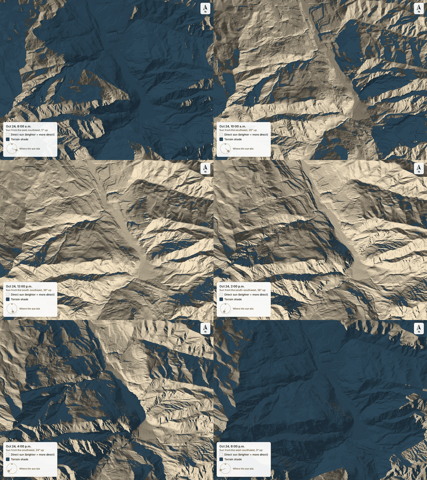
The animation shows the same drainage on opening day of second rifle. On the morning of October 24, legal light comes half an hour before sunrise (6:50 a.m. in Denver, by CPW’s table), but direct sun reaches much of this drainage much later. At 8:30 a.m. nearly two-thirds of it still sits in terrain shadow. The first ground to light up faces northeast and east, not south. By mid-afternoon the picture has flipped toward the south and west faces.
For a hunter, three things follow:
- Glassing. A slope in full sun is easier to glass than one in deep shade, and glassing into a low sun is harder than glassing with it at your back. The morning and evening sides of a basin can call for different spots.
- Your sit. A two-hour glassing session in the shade at 20°F is a much different morning from the same sit in the sun. The shade map shows which seat gets the sun, and when.
- Snow and frost. Sun hits the morning slopes first, so crust softens there first. The shaded side stays frozen and loud longer.
How do you read them together on a topo?
The layers read most clearly as a sequence of questions:
- Slope first: where is the huntable ground? Gentle shelves inside steep country, saddles, and the edges where a face eases off are good places to start.
- Then aspect, for the season: which of those shelves face the way that season tends to favor? Cool faces in early-season heat; sunny faces later, once snow builds.
- Then sun: when does each candidate get sun, and where would you glass it from? Good visibility, ideally with the sun at your back.
- Then everything the terrain layers don’t tell you: water, forage, burns, the distance from roads hunters can drive (which counts for a great deal in a pressured rifle season; see our second rifle guide), and whether the ground is public.
Read well, these three layers narrow a unit in an evening. They make your time spent with boots on ground more effective — but they can’t replace it.
Sources
- About 3DEP products and services — U.S. Geological Survey, 3D Elevation Program, accessed 2026-10-04
- gdaldem: slope, aspect and topographic position — GDAL documentation, accessed 2026-10-04
- Three presentations on geographical analysis and modeling (Tobler's hiking function) — W. Tobler, NCGIA Technical Report 93-1, 1993
- Slope angle — Avalanche.org avalanche encyclopedia, accessed 2026-10-04
- Aspect — Avalanche.org avalanche encyclopedia, accessed 2026-10-04
- Thermal constraints on use of cover types and activity time of elk — E. H. Merrill, Applied Animal Behaviour Science, 1991
- Why do elk seek shelter? The case against the need for thermal cover (Science Findings 22) — USDA Forest Service, Pacific Northwest Research Station; summarizing Cook et al., Wildlife Monographs 141 (1998), 2000
- 2026 Colorado Big Game Hunting Brochure (legal hours, sunrise table) — Colorado Parks and Wildlife, 2026